Danville To Glenmont
September 14, 2025Part of a series about Ohio bike trails
Rating The Ride
Smoothness
7 / 10 Only a few potholes. Nice an smooth at Glenmont and east of Glenmont where the trail seem new. NOTE: Smoothness changes with time and trails could worsen or be repaved
Scenery
8 / 10 About 95% shaded, but monotonous views. Nice views of the creek east of Glenmont.
Seclusion
5 / 10 Not too much traffic but constantly dodging so much horse crap. About 5 or 6 road crossings.
Final score 6.6 / 10
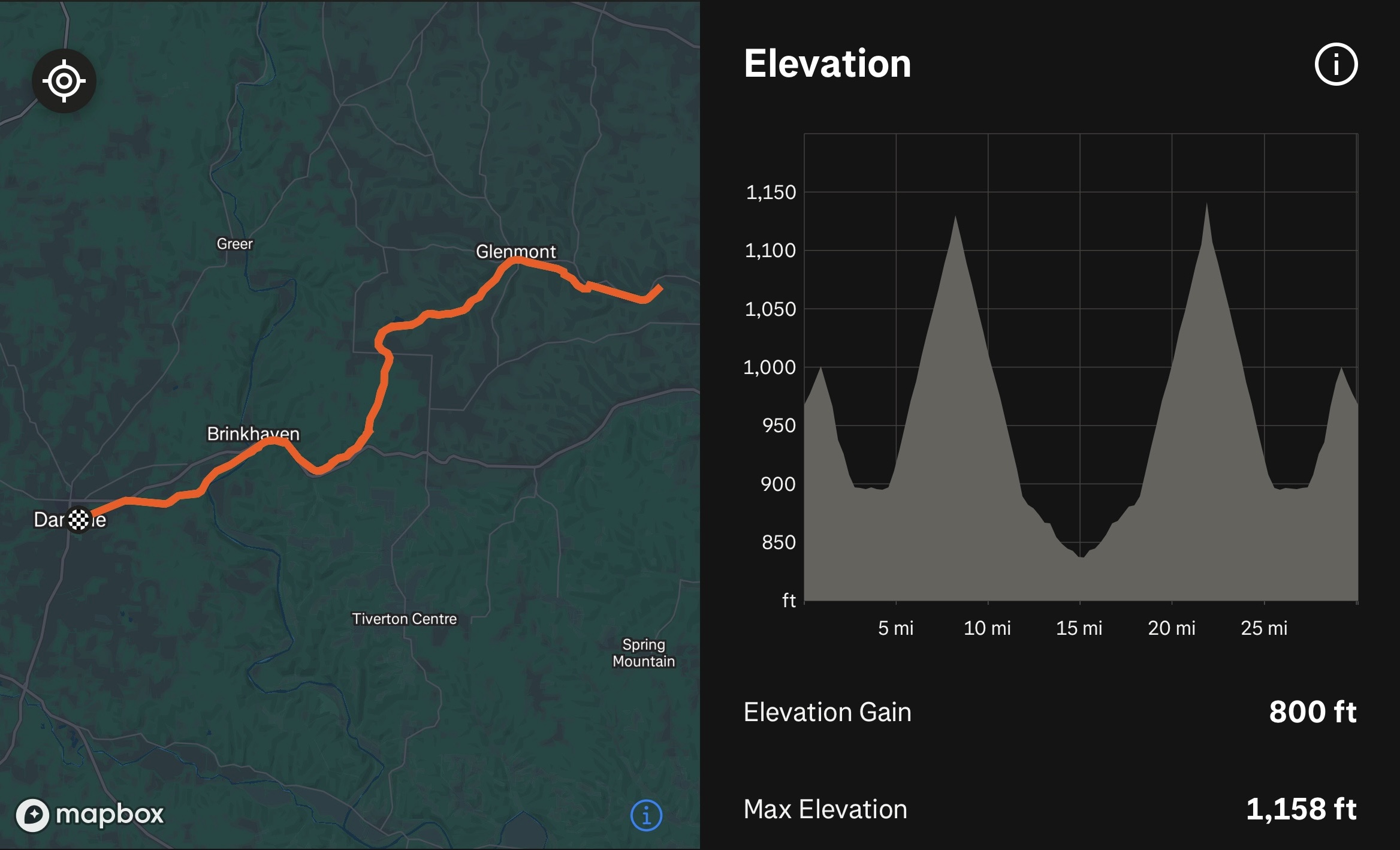
September, 2025 my father-in-law and I biked the Mohican Valley Trail and Holmes County Trail from Danville, Ohio to Glenmont, Ohio, and back.
Our trip was 30.2 miles out-and-back with an elevation gain of 800 ft. We parked at Mohican Valley Trail Danville trailhead: https://maps.app.goo.gl/EFPZEuHYdxpHunzQ8
Restaurants nearby:
- Howard Hilton (cash only!)
- The Pub Kitchen And Tap
- Hangout
TJ Evans Trail
September 06, 2025Part of a series about Ohio bike trails
Rating The Ride
Smoothness
7 / 10 A little rough especially near Johnstown where there are lots of cracks and bumps from tree roots. NOTE: Smoothness changes with time and trails could worsen or be repaved
Scenery
8 / 10 About 80% shaded with some nice scenic views. Nice views of the creek.
Seclusion
6 / 10 Pretty busy with both cyclists and pedestrians. About 5 or 6 road crossings.
Final score 7 / 10
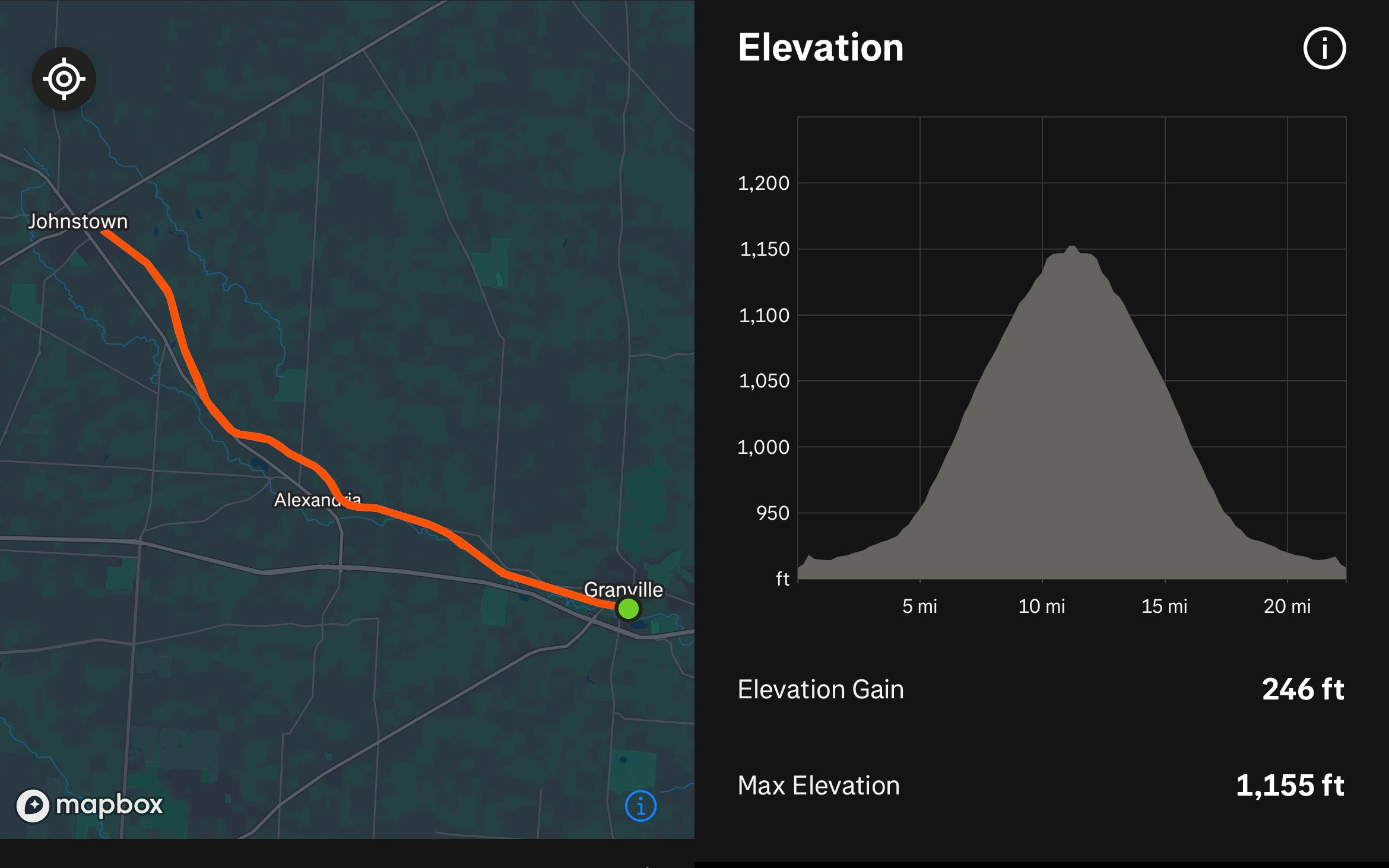
September, 2025 my father-in-law and I biked the TJ Evans Trail from Granville, Ohio to Johnstown, Ohio, and back.
Our trip was 22.43 miles out-and-back with an elevation gain of 246 ft. We parked at TJ Evans Bike Path Parking in Granville: https://maps.app.goo.gl/5f7Ye1fr4f8zHH8j9
Restaurants nearby:
- Day Y Noche
- Three Tigers Brewing Company
- Ray Ray’s Hog Pit
Blacklick Creek Trail
August 31, 2025Part of a series about Ohio bike trails
Rating The Ride
Smoothness
6 / 10 Rough in spots and there was even a 20-yard patch of gravel trail (in Turnberry Community Park) where the asphalt had been removed and not replaced. NOTE: Smoothness changes with time and trails could worsen or be repaved
Scenery
5 / 10 Some nice shaded portions. Travels through a few parks with views of the creek. The trail uses the sidewalks on Hines Rd and Tussing Rd. Noisy due to high-traffic roads near the trail.
Seclusion
5 / 10 Quite crowded. We had planned to bike through Blacklick Woods Metro Park to Livingstone Ave, but we turned around early due to pedestrian traffic in the park. About 5 or 6 road crossings.
Final score 5.3 / 10
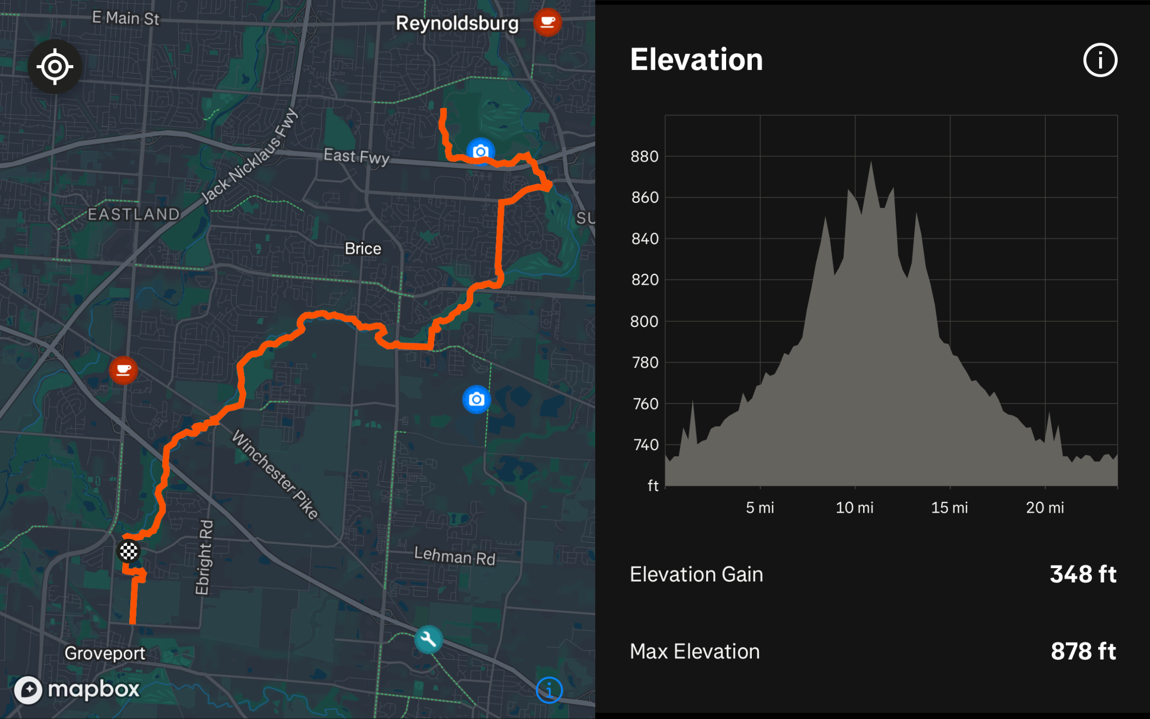
In August, 2025 my father-in-law and I biked the Blacklick Creek Trail from Groveport, Ohio to Reynoldsburg, Ohio and back.
Our trip was 23.89 miles out-and-back with an elevation gain of 348 ft. We parked at Groveport Cruiser Park: https://maps.app.goo.gl/zpTtU7SBTrBTscYu7
Restaurants nearby:
- Combustion Brewery & Taproom
- BrewDog DogTap Columbus
- The Paddock Pub
RECENT POSTS
- Danville To Glenmont
- TJ Evans Trail
- Blacklick Creek Trail
- Roberts Pass Trail
- Alum Creek Trail South
- Southern Half of the Hockhocking Adena Bikeway
- Hockhocking Adena Bikeway Northern-half
- Kokosing Gap Trail
- Adding Background Music to Puzzlescript Games
- Baby Zombie Chicken Jockey Java Minecraft Mod
- Raining Chickens Java Minecraft Mod
- Spawn a Pet Wolf Java Minecraft Mod
- Spigot Server for Java Minecraft Mods
- Python Classes to Javascript Classes
- JUnit Tests with Repl.it Teams for Education
- Canvas How to convert an old Quiz Question Bank to a new Quiz Item Bank
- Node Twitterbot Directions
- FogeyBot Thinks Twitter is the Worst
- Detecting Sentence Structure with Regex
- Game-based Learning Presentation
- Hello Jekyll
- Testing 123
- Grading Multi-Select Questions with Google Forms and Google Sheets
- Puzzlescript Rules
- Using Makey Makey to Teach Electricity
- Makey Makey + Scratch Video Game Projects
- Orbit Simulator
- Market game
- TwineFray: A Battle System for Twine
- Sundown
- Twine Games by Middle School Students
- Twine CSS
- Twine Music and Sound Effects from YouTube
- Twine Pictures, GIFs, and Background Images
- Twine Random Numbers
- Tutorial videos for Spreadsheet Functions and Formulas
- How to Program Twitterbots as an Intro to Computer Science
- Podcast Recommendations
- Coding Twitterbots with Middle School Students
- Educational Games on The Internet Archive
- Typing Games in Scratch
- Scratch Tutorial Videos
- Editing videos with Windows Movie Maker
- How to use iMovie for iPad
- Quick and easy DIY pressure plate switch for Makey Makey and Scratch
- Webcam Motion Pixel Art
- Flipped Classroom Scratch Programming Lessons
- BYOD Music Class Using OhioFi Games
- 3 Methods for Going Paperless in the Classroom
- Dodgeball Cat