Alum Creek Trail South
Part of a series about Ohio bike trails
Rating The Ride
Smoothness
7 / 10 Rough in spots and with some weird dips. NOTE: Smoothness changes with time and trails could worsen or be repaved
Scenery
6 / 10 Mostly nice shaded portions. Travels through a few parks with views of the creek. A little noisy due to high-traffic roads near the trail.
Seclusion
6 / 10 Pretty crowded. About 3 or 4 road crossings.
Final score 6.3 / 10
In August, 2025 my father-in-law and I biked the southern-portion of the Alum Creek Trail from Groveport, Ohio to Bexley, Ohio and back. The full trail is 24.5-miles long, so on this trip we only rode the lower 10-mile portion. The first 2 miles from Groveport Cruiser Park to Three Creeks Metro Park is actually part of the Blacklick Trail.
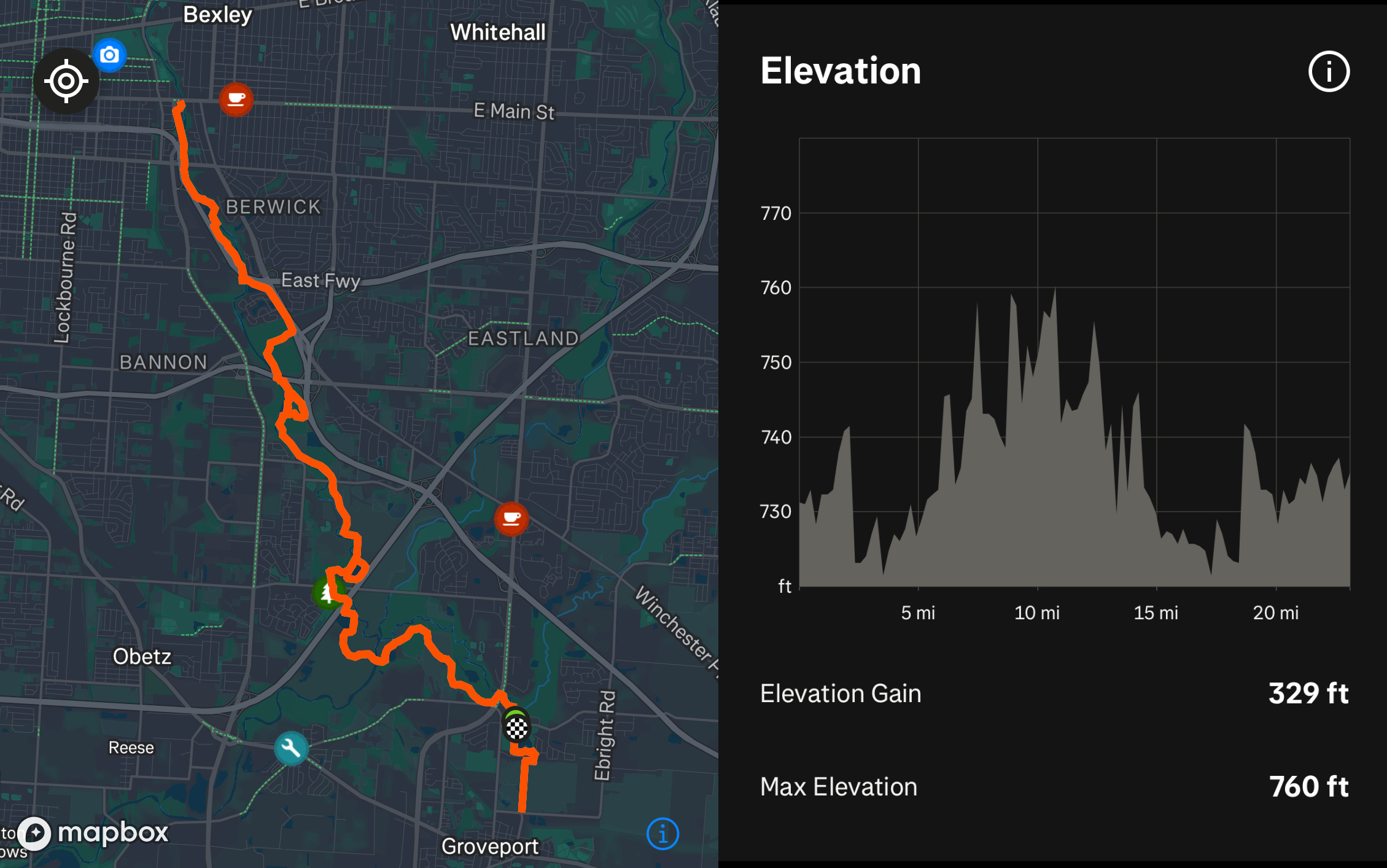
This trip was 23.16 miles out-and-back with an elevation gain of 329 ft. We parked at Groveport Cruiser Park: https://maps.app.goo.gl/zpTtU7SBTrBTscYu7
Restaurants nearby:
- Combustion Brewery & Taproom
- BrewDog DogTap Columbus
- The Paddock Pub
RECENT POSTS
- Danville To Glenmont
- TJ Evans Trail
- Blacklick Creek Trail
- Roberts Pass Trail
- Alum Creek Trail South
- Southern Half of the Hockhocking Adena Bikeway
- Hockhocking Adena Bikeway Northern-half
- Kokosing Gap Trail
- Adding Background Music to Puzzlescript Games
- Baby Zombie Chicken Jockey Java Minecraft Mod
- Raining Chickens Java Minecraft Mod
- Spawn a Pet Wolf Java Minecraft Mod
- Spigot Server for Java Minecraft Mods
- Python Classes to Javascript Classes
- JUnit Tests with Repl.it Teams for Education
- Canvas How to convert an old Quiz Question Bank to a new Quiz Item Bank
- Node Twitterbot Directions
- FogeyBot Thinks Twitter is the Worst
- Detecting Sentence Structure with Regex
- Game-based Learning Presentation
- Hello Jekyll
- Testing 123
- Grading Multi-Select Questions with Google Forms and Google Sheets
- Puzzlescript Rules
- Using Makey Makey to Teach Electricity
- Makey Makey + Scratch Video Game Projects
- Orbit Simulator
- Market game
- TwineFray: A Battle System for Twine
- Sundown
- Twine Games by Middle School Students
- Twine CSS
- Twine Music and Sound Effects from YouTube
- Twine Pictures, GIFs, and Background Images
- Twine Random Numbers
- Tutorial videos for Spreadsheet Functions and Formulas
- How to Program Twitterbots as an Intro to Computer Science
- Podcast Recommendations
- Coding Twitterbots with Middle School Students
- Educational Games on The Internet Archive
- Typing Games in Scratch
- Scratch Tutorial Videos
- Editing videos with Windows Movie Maker
- How to use iMovie for iPad
- Quick and easy DIY pressure plate switch for Makey Makey and Scratch
- Webcam Motion Pixel Art
- Flipped Classroom Scratch Programming Lessons
- BYOD Music Class Using OhioFi Games
- 3 Methods for Going Paperless in the Classroom
- Dodgeball Cat